Trasy trekkingowe Północnego Cypru
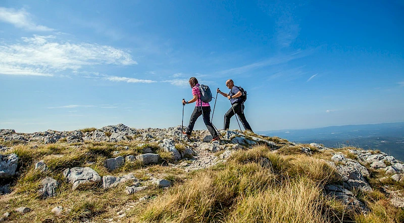
Piękna przyroda i zróżnicowany krajobraz północnej części Cypru nie mogły nie prowadzić do powstania szlaków trekkingowych o różnym stopniu trudności.
W sumie na Północy Cypru jest prawie 600 kilometrów szlaków o różnym stopniu wyposażenia. Przed każdym punktem można znaleźć tablicę informacyjną z mapą, opisem i komentarzami.
Nie znajdziesz tutaj szlaków wyjątkowo trudnych, ale zarazem można udać się zarówno na kilkugodzinny spacer po pięknej ścieżce, jak i na dwutygodniową wędrówkę z noclegiem w namiotach pod gwiaździstym niebem.

Szlaki wielodniowe na Północy Cypru
Szlak Gór Besparmak
Jest to główny szlak trekkingowy wzdłuż Gór Kyreniańskich, dlatego nazywany jest także Szlakiem Gór Kyrenia. Szlak ciągnie się od przylądka Korucam do krańca półwyspu Karpas, a przez całą trasę będą towarzyszyć Ci fantastyczne widoki.
Różne firmy turystyczne na Północy Cypru organizują wędrówki wzdłuż szlaku o różnym poziomie komfortu - z noclegiem tylko w namiotach lub kombinowane z pobytami w hotelach i kempingach. Istnieje możliwość zakupu wycieczki z towarzyszeniem samochodu, wówczas nie trzeba nosić całego ekwipunku w plecaku.
Cały szlak można pokonać w ciągu dwóch tygodni, ale część z niego jest podzielona na odcinki po 5-7 dni. Można go przejść samodzielnie, szlak jest oznakowany zielono-białymi znakami.
Bellapais - Boğazköy
Jest to ośmogodzinny szlak, który logicznie można podzielić na kilka dni, aby móc bez pośpiechu podziwiać piękno. Długość trasy to nieco ponad 25 kilometrów, a suma przewyższeń wynosi nieco ponad kilometr.
Krótkie szlaki na jeden dzień
Karmi - zamek św. Hilariona
Popularna trasa z jednej pięknej lokalizacji do drugiej. Całkowite przewyższenie wyniesie 350 metrów, trwa około 3 godzin. O samym zamku można przeczytać w naszym artykule.
Zeytinlik - zamek św. Hilariona
Kolejny szlak do zamku, ale zaczynający się poniżej wsi Karmi, co oznacza większe przewyższenie - 650 metrów, a różnica wysokości wyniesie 900 metrów. Długość trasy to 14 kilometrów.
Bellapais Trail
Rozpoczyna się przy opactwie Bellapais i obejmuje okoliczne piękności. Długość to około 11 kilometrów z przewyższeniem 750 metrów.
Bellapais - zamek Buffavento
Trzynastokilometrowy szlak rozpoczynający się od wsi Bellapais, z przewyższeniem ponad 600 metrów. Można połączyć go z wizytą w zamku Buffavento, ale należy pamiętać, że podróż tam i z powrotem zajmuje 4,5 godziny, a dodatkowo trzeba będzie podejść do samego zamku z parkingu - o szczegółach tego podejścia opowiadaliśmy w artykule o Buffavento.
Alevka
Starts at the herbarium in the village of the same name and passes through the ancient Armenian monastery of Surb Magar. The length is 8 kilometers with an elevation gain of 450 meters.
Esentepe - Antiphonidis
It lasts from the village of Esentepe to the Antiphonidis monastery, which today is a museum. It can be combined with a visit if timed to coincide with the monastery's working hours. The total elevation gain is 700 meters, the length is 13 kilometers.
Yerenköy
The trail starts at the village of Küçük Erenköy, at the Sinya guesthouse, with a total length of only 6 kilometers and an elevation gain of 350 meters. An easy track with readable yellow markings.
Karşıyaka
Also a short 6-kilometer trail from the village of Karşıyaka. Notable for the ruined Sina monastery on the way. Elevation gain - 400 meters.
Lapta - Başpınar
The track starts in Lapta, at the square of the old Başpınar spring. 9 kilometers and a 900-meter elevation gain are complemented by challenging sections, the route cannot be considered easy. But on the way, you will encounter abandoned churches.
Arapköy Circular Trail
Starts from the village of Arapköy and goes mostly in a circle. The route length is just under 8 kilometers, and you can complete it in 2.5 - 3 hours depending on your preparation.
Frequently Asked Questions About Trekking and Activities
What to take on a trekking trip?
Even a short hike on marked trails requires preparation, especially if you are going for a walk in hot weather. Pay close attention to your footwear, and if necessary, consider trekking poles. Also, take plenty of water with you, even if the weather is overcast and not hot.
Are there any hiking apps in Northern Cyprus?
Yes, but only for users of the Andriod operating system: in Google Play there is the app North Cyprus Hiking Trails, you can download it for free.
What other activities are there in Northern Cyprus?
If you want to see all the routes described above from a bird's-eye view, we recommend paragliding - flights pass right over the Kyrenia Range, read about it in our article.
And also - subscribe to our Telegram channel and Instagram, where we talk about the unusual places of Northern Cyprus and give useful advice on life on the island.

