
Trekking Routes of Northern Cyprus
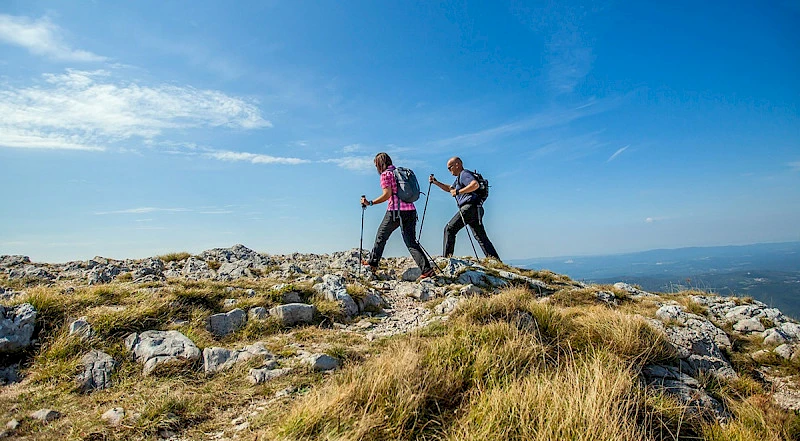
The beautiful nature and diverse terrain of northern Cyprus have naturally led to the creation of trekking routes of varying levels of difficulty.
There are nearly 600 kilometers of trails of different levels of equipment in Northern Cyprus. Before each point, you can find information boards with maps, descriptions, and comments.
You won't find extremely difficult options, but you can embark on a hike for a few hours along a beautiful trail or spend two weeks camping under the starry sky.
Multi-day routes in Northern Cyprus
Besparmak Mountain Trail
This is the main hiking route along the Kyrenia Mountain Range, also known as the Kyrenia Mountain Trail. The trail stretches from Cape Korucam to the tip of the Karpas Peninsula, offering fantastic views throughout the entire route.
Various tourist companies in Northern Cyprus organize hikes along the trail with different levels of comfort, including camping-only or combined with stays in hotels and campgrounds. It is also possible to purchase a tour with car support, so you don't have to carry all the equipment in your backpack.
The entire trail can be completed in two weeks, but it can also be divided into segments of 5-7 days. It is possible to hike it independently, as the route is marked with green and white signs.
Bellapais - Bogazkoy
This is an eight-hour route that can be logically divided into a couple of days to fully enjoy the beauty along the way. The length of the route is just over 25 kilometers, with a total elevation gain of just over a kilometer.
Short one-day routes
Karmi - St. Hilarion Castle
A popular route from one beautiful location to another. The total elevation gain is 350 meters, and the hike takes about 3 hours. You can read more about the castle in our article.
Zeitunlik - St. Hilarion Castle
Another trail to the castle, starting below the village of Karmi, resulted in a higher elevation gain - 650 meters, with a total elevation change of 900 meters. The length of the trail is 14 kilometers.
Bellapais Trail
Starts at Bellapais Abbey and includes the surrounding beauty. The trail is approximately 11 kilometers long with an elevation gain of 750 meters.
Bellapais - Buffavento Castle
A 13-kilometer trail starting from the village of Bellapais, with an elevation gain of just over 600 meters. It can be combined with a visit to Buffavento Castle, but please note that the round trip takes 4.5 hours, and you will need to hike up to the castle from the parking lot - we have covered the specifics of this ascent in our article about Buffavento Castle.
Alevkaya
Starts at the herbarium in the village of Alevkaya and passes through the ancient Armenian monastery of Surb Magar. The trail is 8 kilometers long with an elevation gain of 450 meters.
Esentepe - Antiphonitis
Runs from the village of Esentepe to the Antiphonitis Monastery, which is now a museum. It can be combined with a visit if you time it during the monastery's opening hours. The total elevation gain is 700 meters, and the trail is 13 kilometers long.
Yerenkoy
The trail starts at Küçük Erenköy village, near Sinya guesthouse, with a total length of 6 kilometers and an elevation change of 350 meters. It is an easy track with visible yellow markers.
Karşıyaka
Another short 6-kilometer trail from Karşıyaka village. It is notable for the ruined Sina Monastery along the way. The elevation change is 400 meters.
Lapta - Bașpınar
The track starts in Lapta, at the square of the old Bașpınar spring. With a distance of 9 kilometers and an elevation change of 900 meters, it includes challenging sections, so the route cannot be considered easy. However, you will come across abandoned churches along the way.
Arapköy Circular Trail
It starts from Arapköy village and mostly follows a circular path. The route is slightly less than 8 kilometers long, and depending on your fitness level, it can be completed in 2.5 to 3 hours.
Frequently Asked Questions about Trekking and Activities
What should I bring on a trekking trip?
Even a short hike on marked trails requires preparation, especially if you are going during hot seasons. Pay close attention to your footwear, and if necessary, consider trekking poles. Also, bring an ample water supply, even if the weather is cloudy and not hot.
Are there any hiking apps for Northern Cyprus?
Yes, but only for Android users: there is the North Cyprus Hiking Trails app available for free on Google Play.
What other activities are there in Northern Cyprus?
If you want to see all the routes described above from a bird's-eye view, we recommend paragliding. Flights take place over the Kyrenia Range, and you can read about it in our article.
Also, don't forget to follow our Telegram channel and Instagram, where we share information about unique places in Northern Cyprus and provide useful advice about life on the island.
Author
Born and raised in Yekaterinburg, visited more than 40 countries, lived in the USA for some time, and in 2022, moved to Cyprus. Education: Ural State University (now Ural Federal University), Faculty of Political Science and Sociology. Professional Experience: Since 2008, worked in the fields of…