Mount Olympus in the Republic of Cyprus: Location, How to Get There, and Nearby Attractions
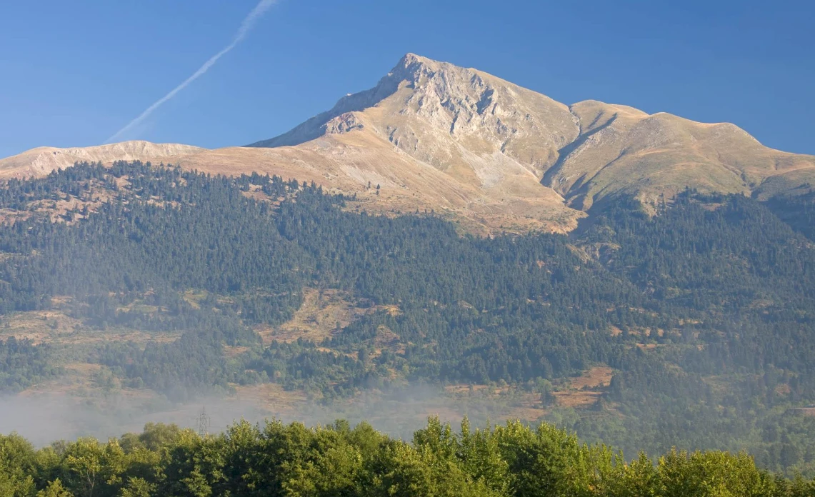
Mount Olympus, or Chionistra, is the highest point in the Republic of Cyprus, standing at an elevation of 1,952 m. You can drive to the summit area via the road from Troodos, but the peak itself, which houses a British radar station, is closed to public access. For a standard visit, it is better to plan for the observation decks and the legal Artemis Trail and Atalanti Trail routes. In summer, people come here for the cool air and views, while in winter, they visit for the snow and skiing infrastructure; however, on snowy days, snow chains or a 4x4 vehicle may be required on the access roads.
Below is practical information for a trip to Olympus in the Republic of Cyprus: exactly where the mountain is located, whether you can climb to the top, which trails to choose, and what is convenient to see nearby in one day.
- Where is Olympus located
- Is it possible to climb to the summit
- Legal routes and walks
- What is important to know in winter
- What to see nearby
- Useful services
- Frequently Asked Questions
Where is Olympus located
Olympus is located in the Troodos Mountains in the Republic of Cyprus. The name Chionistra is also used and refers to the same peak. Administratively, the summit area belongs to the Platres territory in the Limassol district.
The height of Olympus is 1,952 m, making it the highest point on the island. For a trip, tourists usually head toward Troodos Square, which serves as the starting point for access to observation points, ski infrastructure, and nature trails.
In summer, it is noticeably cooler here than on the coast, making it convenient to plan the trip as a day route from Limassol, Nicosia, Larnaca, or Paphos.
Is it possible to climb to the summit
Free access to the very highest point is restricted because a British radar station operates at the peak. You should not approach the closed zone directly or take photographs of the military infrastructure.
For a regular visitor, the practical format is as follows: drive to the Troodos area, stop at the legal viewpoints, and walk one of the circular routes around Olympus. This provides views of the slopes, forest, valleys, and the high-mountain part of Troodos without violating any restrictions.
This is why, in this article, it is better to focus not on "climbing the closed peak," but on walking the nature trails near the summit.
Legal routes and walks
Near Olympus, it is most convenient to choose circular trails that are suitable for a self-guided half-day or full-day trip.
Artemis Trail
The Artemis Trail circles Olympus at an altitude of about 1,850 m. The route length is 7 km, and the typical completion time is 2.5–3 hours. The start is located about 300 m from the junction of the road to Chionistra and the Troodos–Prodromos road, where parking is available.
This is one of the most convenient routes for a first introduction to the high-altitude part of Troodos. Along the way, you will find information boards, rare flora, and views spanning different directions of the mountain range.
Atalanti Trail
The Atalanti Trail is longer: about 14 km, with an estimated time of up to 5 hours. It starts and ends at Troodos Square and runs lower than the Artemis Trail, circling Olympus through the forested zone.
This option is suitable for those who want a full-scale hike with a large number of viewpoints. There is drinking water and spots for short rests along the route.
Sightseeing trip without long hiking
If a long route isn't needed, you can drive to the Troodos Square area, go up to the observation decks near Olympus, walk a short section of a trail, and then continue your trip to neighboring villages. This format is convenient for families, trips with children, and winter days when the weather changes rapidly.
How to do it
- Drive to the Troodos Square area by car early in the morning, especially on weekends and in winter.
- Check the weather and mountain road conditions before setting off.
- For a short walk, choose the observation points and the beginning of the Artemis Trail.
- For a long route, plan for the Atalanti Trail and bring water, a warm layer of clothing, and shoes with good grip.
- Do not enter closed zones near the radar and do not photograph military objects.
What is important to know in winter
The Olympus area changes most significantly in winter. On snowy days, some roads in Troodos may be open only to vehicles with snow chains or 4x4 drive. This applies to roads such as Platres–Troodos, Karvounas–Troodos, and Prodromos–Troodos.
The skiing infrastructure of the Cyprus Ski Club operates on Olympus. During the season, four lifts are used: Zeus, Hera, Aphrodite, and Hermes. Snow coverage on the mountain is not consistently stable throughout the season, so in winter, it is better to check the actual opening of the slopes on the day of your trip rather than relying solely on the calendar.
Even if skiing isn't part of your plan, it makes sense to go to Olympus in winter for the snow, a short walk, and the views. However, you should not plan such a trip without warm clothing and checking the road situation.
What to see nearby
A trip to Olympus is easily combined with other locations in Troodos.
Troodos Geopark Visitor Centre
The Troodos Geopark Visitor Centre helps you better understand the geology of the area and the layout of the nature routes. It is a good option for a short stop at the beginning or end of your trip, especially if you want to add an educational component to your walk.
Troodos UNESCO Global Geopark
Olympus is located within the Troodos UNESCO Global Geopark. This is one of the primary natural areas of the Republic of Cyprus, known for its rare geology, pine forests, viewpoints, and mountain routes.
Platres and Prodromos
If you want to do more than just visit the summit and wish to spend the whole day in the mountains, it is convenient to add a stop in Platres or Prodromos. This is a typical format for a trip involving lunch, a walk, and visiting nearby trails or monasteries.
UNESCO-listed churches of Troodos
The Troodos region is home to famous Byzantine churches included in the UNESCO World Heritage list. They are easy to include in the same route if you want to combine nature with a cultural program.
Useful services
For a trip to Troodos, it is most common to pre-book a car, transfer, and mobile internet. This is particularly convenient for the mountain region because the route usually includes several stops and does not always align well with public transport.
- To rent a car in the Republic of Cyprus, you can compare options here: Localrent.
- For airport transfers or travel between cities, you can check conditions here: KiwiTaxi.
- For mobile internet without a local SIM card, you can look into eSIMs here: Drimsim.
- For booking hotels in the Troodos, Platres, and Prodromos area, you can check options here: Ostrovok.
Frequently Asked Questions
What is the height of Mount Olympus in the Republic of Cyprus?
The height of Olympus is 1,952 m.
Is it possible to climb to the very summit?
Free access to the peak itself is restricted due to a radar station. For tourists, legal routes and observation points around the summit are appropriate.
When is the best time to go to Olympus?
For walking and hiking, the period from March to November is most often chosen. In winter, people visit for the snow and skiing infrastructure, but you must check road conditions and weather before traveling.
Is an off-road vehicle needed for the trip?
In summer, a regular car is usually sufficient. In winter, on snowy days, snow chains or a 4x4 may be required.
Are there hiking trails nearby without a difficult climb?
Yes. The most convenient option for most tourists is the Artemis Trail. It is a circular route that does not require entering the closed zone at the summit.
Can I get there by public transport?
Direct public transport to the Olympus area is limited; therefore, for a practical trip, a car or individual transfer is more convenient. Without a car, the route usually becomes longer and less flexible.
Author

I am a person who is not afraid to change life when my heart tells me that something greater lies ahead. I am originally from Belarus. I have journeyed from pedagogical and economic education to the financial sector and many years of work in logistics — a world where everything moves, changes,…