Avakas Gorge in the Republic of Cyprus
If you are looking for the most famous and one of the most impressive gorges in the Republic of Cyprus, people are usually referring to Avakas on the Akamas Peninsula. For a visitor, the practical details are more important than the debate over the "deepest" label: the official route through the gorge is linear, 1.2 km one way, with an average round-trip walking time of about 2 hours. The difficulty level is 1–2, and the best period to visit is from March to November. It is not advisable to go there after rain due to slippery rocks, the risk of rockfalls, and sudden water level rises.
Below is what makes Avakas Gorge remarkable, how the route is structured, how to prepare for the walk, and the most convenient ways to get there.
- Structure of the Gorge
- Route Through Avakas Gorge
- Flora and Fauna
- How to Get There
- Frequently Asked Questions
Structure of the Gorge
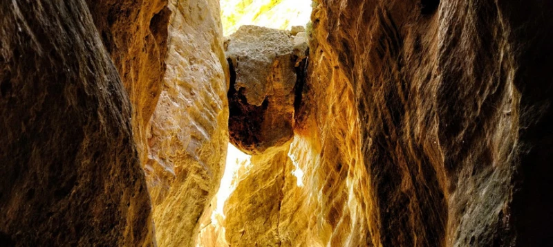
Avakas Gorge is located on the Akamas Peninsula in the western part of the Republic of Cyprus. It is a narrow limestone canyon formed by the erosion of the Avgas riverbed. The route passes through a natural corridor between high rock walls, and in the final sections, the trail goes directly along the riverbed, where water usually remains for most of the year.
The main feature of Avakas is the contrast between the open dry valley at the entrance and the cool, shaded part inside the canyon. In narrow spots, the walls close in sharply, making the gorge look much more spectacular than most ordinary walking trails by the sea. This is why it is often considered one of the most expressive natural routes in the Republic of Cyprus.
Route Through Avakas Gorge
The official Avakas Gorge Trail is linear. Its length is 1.2 km one way, or 2.4 km round trip. The first 700 m are considered easier, while the difficulty increases further on due to crossing the riverbed and slippery rocks.
| Parameter | Value | Comment |
|---|---|---|
| Route Type | Linear | Return via the same trail |
| Length | 1.2 km | 2.4 km round trip |
| Duration | About 2 hours | Usually longer with stops |
| Difficulty | 1–2 | No serious climbs, but with slippery sections |
| Best Period | March–November | The route can be dangerous after rain |
| Starting Point | Avakas Gorge | There is a designated parking lot at the start of the route |
Non-slip shoes are required for the walk. Inside the gorge, you will encounter wet rocks, a stream, and areas where you need to choose your steps carefully. Official route materials specifically state that there is a risk of falling rocks inside the gorge, especially on and immediately after rainy days.
How to do it
- Drive to the parking lot near the gorge via the Agios Georgios Pegeias – Toxeftra road.
- From the point where the sign for Toxeftra Bay begins, turn onto a narrow dirt road for about 900 m.
- Leave your car in the designated parking lot and proceed on foot along the route.
- Bring water, comfortable shoes, and a phone with an offline map or a pre-opened point in Google Maps.
- Do not enter the gorge if rain or a storm warning is in the forecast.
Flora and Fauna
Avakas Gorge is part of the Natura 2000 protected area. Along the route, you will find local species of shrubs and trees, including juniper, mastic, oleander, storax, and other typical Akamas plants. Official trail descriptions also mention rare endemic species.
Regarding animals and birds, you may encounter foxes, hares, hedgehogs, lizards, as well as local and migratory birds in the gorge area. For the average visitor, it is not a zoo or a guaranteed wildlife sighting, but it is the combination of rocks, water, and dense vegetation that makes the route one of the most vibrant natural areas in the western part of the Republic of Cyprus.
How to Get There
The gorge is located in the Paphos district, on the Akamas Peninsula. In practice, it is most convenient to get there by car, as the last section of the journey is via a narrow dirt road, and public transport does not drop you off directly at the trail entrance. If you want to see the current starting point of the route, it is easiest to open it in Google Maps.
If you are planning a route through the western part of the Republic of Cyprus and want to reach Avakas without relying on taxis, it is convenient to compare car rentals in advance via Localrent. For traveling to natural locations in Akamas, this is usually more practical than trying to adapt to infrequent bus transfers.
For the walk through the gorge, it is also worth considering basic travel essentials in advance. You can arrange medical insurance for the trip before departure, for example via Tripinsurance, and for navigation and connectivity on the road, it is convenient to set up a travel eSIM in advance, for example through Drimsim.
Frequently Asked Questions
Is it really the deepest gorge in the Republic of Cyprus?
In tourist publications, Avakas is most often cited as the deepest gorge on the island. From a practical standpoint, what matters more is that it is one of the most famous and spectacular natural canyons in the Republic of Cyprus with an official hiking route.
How long does the walk through Avakas Gorge take?
The official duration of the route is about 2 hours. If you stop frequently for photos or walk at a leisurely pace, it may take more time.
Can I complete the route in regular sneakers?
It is better to choose shoes with good grip. Inside the gorge, there are slippery rocks, water, and crossings along the riverbed, so flat soles are uncomfortable and unsafe.
Is Avakas suitable for children?
The route is possible for children who are confident walking on uneven surfaces, but it is not a walk along a promenade. Inside the gorge, there are wet rocks, narrow sections, and places where constant adult supervision is required.
When is it best not to go into the gorge?
After rain, when there is a risk of thunderstorms, and on days with adverse weather warnings. Water in the riverbed can rise quickly, and the risk of slipping and rockfalls becomes higher.
Can I drive right up to the trail entrance?
Usually, people drive to the designated parking lot, and from there, the route is on foot. Part of the road to the start of the trail is unpaved, so before the trip, it is useful to open the point in Google Maps and assess the route in advance.
Author

I am a person who is not afraid to change life when my heart tells me that something greater lies ahead. I am originally from Belarus. I have journeyed from pedagogical and economic education to the financial sector and many years of work in logistics — a world where everything moves, changes,…